
The Tropics Are Heating Up: From a Slow Start to a Surge in Activity
- Aug 8, 2025
- 2 min read
Updated: Aug 9, 2025
The 2025 Atlantic hurricane season has, until now, been relatively quiet. While forecasters expected an active year thanks to record-warm ocean waters and a transition to La Niña conditions, the first two months brought fewer named storms than average. Much of June and July passed with minimal tropical development, giving coastal communities a welcome break and perhaps a false sense of calm. But as we turn the corner into August—the heart of hurricane season—the atmosphere is showing signs that this lull is ending. Historically, more than 80% of hurricanes form between early August and mid-October, and 90% of the strongest storms occur during this window. In other words: the most active stretch of the season is just beginning.
Now, the National Hurricane Center’s latest Tropical Weather Outlook hints that the tropics are waking up. As of August 8, 2025, the Atlantic basin has no active named storms, but multiple systems are under watch. A weak low-pressure area sits a few hundred miles off the coast of North Carolina, generating scattered showers and thunderstorms. While development is expected to be slow, it’s moving northeast at 10–15 mph and could briefly organize before merging with a frontal boundary later this weekend.
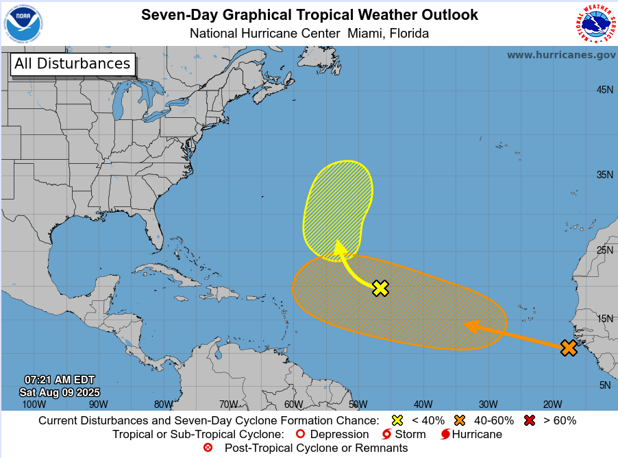
Farther east, the Main Development Region (MDR) is starting to show life. A tropical wave—currently tagged Invest 96L—is in the central Atlantic with a 60% chance of development over the next five days. Forecast models suggest it will track northwest into open waters, possibly passing near Bermuda next week. While it poses no immediate U.S. threat, it’s an early signal that African easterly waves are beginning to roll off the continent with more vigor.
Another disturbance in the eastern tropical Atlantic also has a high chance of development, with the NHC giving it around a 60% probability in the coming days. This is significant because systems forming this far east often have more time over warm water, allowing them to intensify as they move westward.
What’s fueling this uptick? Sea surface temperatures across much of the Atlantic and Gulf of Mexico are 2–4°F above average, with some pockets near southwest Florida reaching an astonishing 90°F. These marine heat waves act as high-octane fuel for tropical cyclones, especially when paired with decreasing wind shear—a combination now taking shape.
Meteorologists are also watching the Madden-Julian Oscillation (MJO), a global atmospheric pattern that can enhance tropical activity. The MJO is expected to move into a favorable phase for the Atlantic in mid-August, potentially adding another spark to the tropical ignition.
While no system currently poses an imminent landfall threat, the pattern is shifting toward a more active and volatile period. The slow start to the 2025 season may be giving way to a rapid ramp-up, and history tells us that some of the most impactful hurricanes form in late August and September.

For now, the takeaway is simple: the tropics are heating up—and with the season’s peak ahead, it’s time for all coastal residents to check preparedness plans, review evacuation routes, and stay tuned to official forecasts. The quiet days may be behind us.


